West Tanami Project (Gold, REE & Base Metal) – Western Australia
In a snapshot
- A district scale project ~1900kms north-east of Perth, 200kms south-east of Halls Creek in Western Australia.
- The Company holds 1,634km2 of prospective tenure, adjacent to a >19M oz goldfield which includes the >8M oz Callie Deposit (Newmont), and 55kms from the Browns Range Rare Earth Element Deposit (Northern Minerals).
- The Company is exploring for large scale orogenic sediment hosted gold deposits.
- Last explored 1980’s to early 2000’s by Goldfields, Barrick and Tanami Gold NL.
- 85% of the project has shallow transported cover, 2-5m depth, which is enough to obscure a gold system – and provides an opportunity for discovery.
- No Diamond or RC drilling has been completed on the project, historically.
- Multiple targets generated based on Callie geochemical signature.
- Potential for REE’s with 95kms of strike identified.
Killi owns 100% of the West Tanami Gold Project in the north-east of Western Australia. The land holding totals 1,634km2 of granted tenure over 100km strike of the major gold corridor, Tanami Fault System, with existing gold endowment of the Tanami Gold Province greater than 19M oz Au.
Within the district there are multiple gold deposits which include Callie Gold Mine (Newmont, ~13Moz Au), the Tanami Goldfields (3M oz Au), Twin Bonanza (1.5M oz Au) and the Coyote and Kookaburra mines (Black Cat Syndicate, ~1M oz Au).
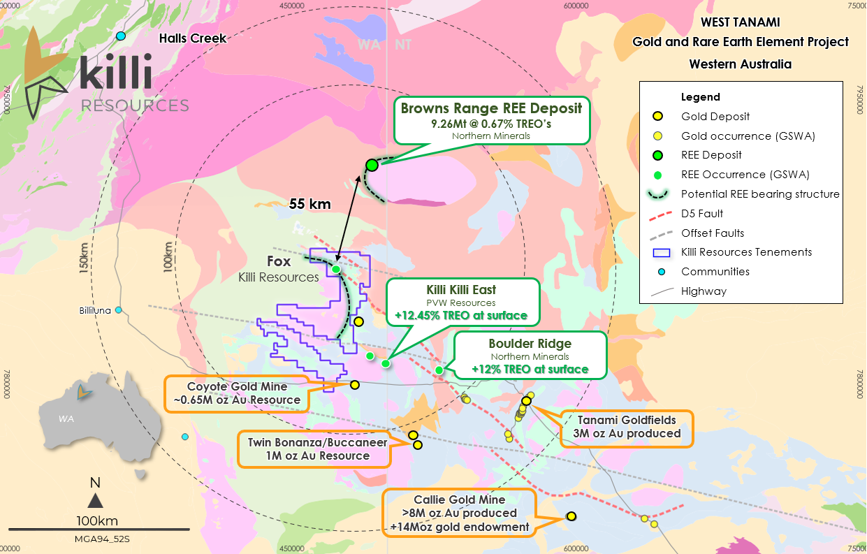
Aside from gold opportunity, recent work completed by explorers in the area have highlighted the potential for hydrothermal Rare Earth systems within the district.
85% of the tenement package is covered by shallow transported cover (12-15m depth) which provides an opportunity for the discovery of a new mineralisation system.
West Tanami - Gold Targets
Killi has generated multiple gold targets by using similar analogues to that of Callie Gold Mine (Newmont), Coyote (Northern Star) and Kookaburra (Northern Star), as these systems have unique styles of mineralisation.
Three distinct corridors have been established over the project to prioritise Killi’s gold exploration strategy and represent the major gold systems they are associated with, Callie Corridor, Kookaburra Trend and the Coyote Corridor.
Multiple geochemical anomalies are evident throughout the project, at Oracle, Fox, Navajo, Hermes, Pennacock, and Pawnee.
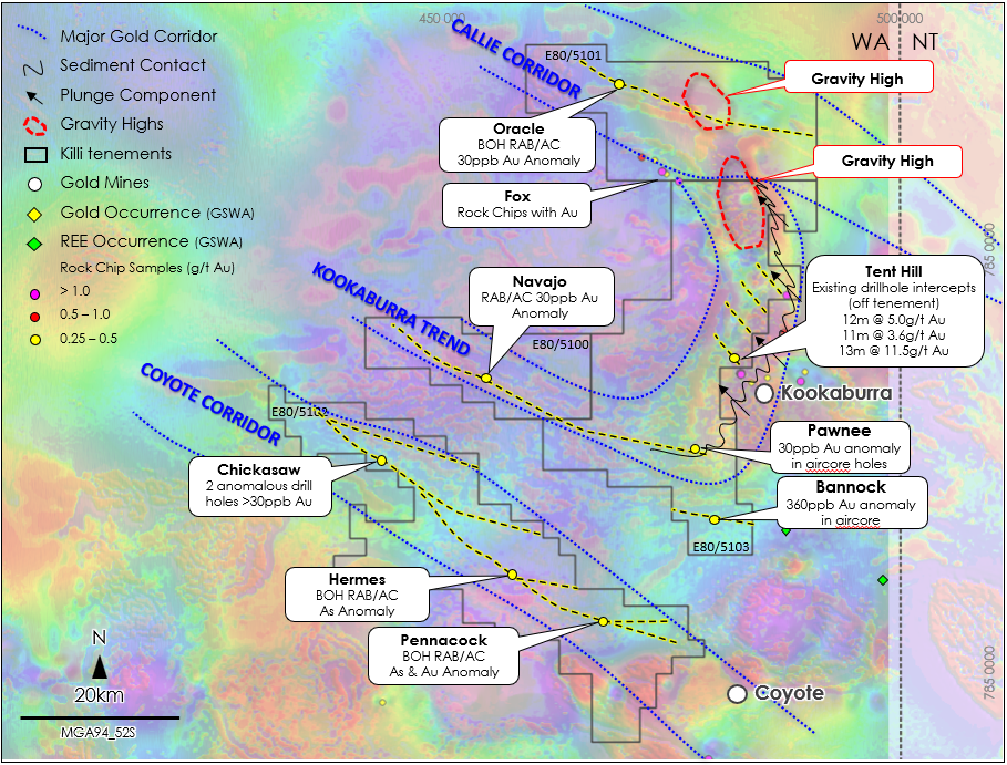
1. Callie Corridor
- Main mineralising fault from the Callie Gold Mine crosses through the centre of the northern tenement held by Killi, more commonly known as the D5 fault structure.
- At Oracle Barrick Gold identified a 7.5km strike drill anomaly >30ppb Au, by completing a wide spaced (500m grid) shallow first-pass aircore drill Program. Best results returned include 9m @ 93.1ppb Au from 56m (BLAC1777), and 10m @ 31.6ppb Au from 83m (BLAC1786) downhole.
- At Fox prospect the target covers the contact between a large scale granite with the Killi Killi Formation. Rock chips collected by the geological survey returned– 2.2g/t Au, 2.48g/t Au, & 0.7g/t Au with 4.5g/t Ag at surface.
- The ‘D5 Fault’ is interpreted to cross-through the northern tenement at the Trickster prospect, with no existing drilling over the area.
2. Coyote Corridor
- Lies adjacent to the Coyote Gold mine (Black Cat Syndicate), associated with high gravity responses from geophysical surveys, representing intrusive bodies within the sedimentary sequence.
- Wide spaced (1600m x 100m), shallow RAB/AC holes over magnetic anomalies, identified As (>100ppb) and Au (>50ppb) anomaly.
- At the Hermes prospect the best intercepts from the RAB drilling includes: 3m @ 1.05g/t Au from surface (BRPH2817) & 3m @ 1.0g.t Au from 34m (SSPH0755).
- Rock chip samples include: 1,000ppm W, 40ppb Au, 37ppm Bi, 5,700ppm As, 480ppm Cu, 780ppm Zn – All significant pathfinder elements.
3. Kookaburra Trend
- Lies adjacent to the Kookaburra Gold Deposit (Black Cat Syndicate).
- Two additional gravity high responses have been identified north of Kookaburra on Killi tenements.
- Folded sedimentary sequences with gold mineralisation plunging into Killi ground occur along the eastern margin of the tenure at the Tent Hill
- At Navajo there is a 10x background gold RAB/AC anomaly, 4km in length and 0.3km in width.
- Lyrebird – (off the tenement) intercepts of:
- 12m @ 5.0g/t Au (LGB0427) – 600m from Killi tenement
- 11m @ 3.6g/t Au (LGC0052)
- 13m @ 11.5g/t Au (LGC0073) – 3km from Killi tenement
Remain untested on Killi ground.
West Tanami - REE’S
In a snapshot
- Recent work completed in the Tanami region has highlighted the potential for a significant Rare Earth discovery in the Tanami region, specifically West Tanami.
- Collectively 95kms of rare earth strike has been identified within the Killi tenements.
- Three prospects have been initially determined for rare earth mineralised potential on the tenement package being Oracle, Bannock and Chickasaw, due to their proximity to PVW Resources structure and the presence of a geological unconformity.
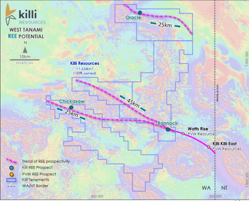
While the gold opportunity is significant for the Company, the potential for rare earths is also highly promising.
Recent developments and successes in the region have identified the potential for hydrothermal related Rare Earth Element (REE) deposits within the sediments of the Tanami Group. Specifically, the unconformity between the Pargee Sandstone and the Killi Killi Formation.
A district wide evaluation of the geochemical datasets and work completed by other companies is currently underway. Historic rock chip programs were designed to target the unconformity of the sandstone with the Killi Killi Formation on the northern tenements of the Killi package, for the purposes of uranium exploration. Therefore, these rock chip samples were in part analysed for REE’s.
Geological mapping provided by the Geological Survey of Western Australia confirms the consistency of the proposed contact across the tenement package, GSWA 1:100k map sheets ‘Slatey Creek’ and ‘Balwina’ indicate the estimated location of the prospective unconformity highlighted by PVW Resources.
The Bannock Prospect occurs on along strike to the west from the Killi Killi East and Watts Rise prospects on the PVW Resources (PVW) Tanami Project where high grade TREO rock chip results have been returned. The structure/unconformity is interpreted to carry on from the tenement boundary with PVW for a further 45km into Killi’s ground.
Chickasaw is the third REE prospect at the project, located on tenement E80/5102. Existing mapping provided by the GSWA 1:100k map sheet ‘Balwina’ indicates the presence of a sandstone within the Killi Killi Formation.